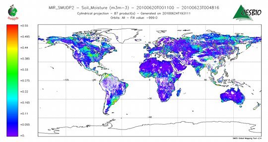
Nature: The European Space Agency’s Soil Moisture and Ocean Salinity ( SMOS) spacecraft has released its first map of Earth’s soil moisture. Launched in November 2009, SMOS derives soil moisture by measuring and analyzing the microwave spectrum emitted by the ground. In the map shown below, blue connotes dry soil; red connotes wet soil. The map was taken on 21 June, when the US midwest was unusually wet and the UK southeast was unusually dry.
For the UNESCO section chief, “striking a balance between global coherence and respect for national ownership and cultural diversity is both essential and complex.”
May 13, 2026 01:46 PM
Get PT newsletters in your inbox
PT The Week in Physics
A collection of PT's content from the previous week delivered every Monday.
One email per week
PT New Issue Alert
Be notified about the new issue with links to highlights and the full TOC.
One email per month
PT Webinars & White Papers
The latest webinars, white papers and other informational resources.